
It. Is. Hot. Here.
County to see at least dozen straight days of 100°
Summer’s here and blistering heat has hit Kingfi sher County for an extended period of time.
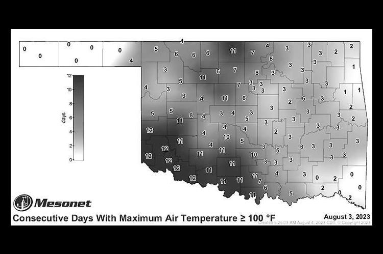
According to the Mesonet website, Kingfisher has exceeded an air temperature of 100 degrees for 11 consecutive days as of Thursday, Aug. 3.
That number is expected to climb to at least 13 as forecasts for Friday and Saturday (both after press time) had high temperatures well above 100.
The string of 11 days was among multiple locations tied for second-most in the state. They were behind the likes of Erick, Hollis, Mangum, Altus, Tipton and Grandfield, all in far southwestern Oklahoma, which were sitting at 12 straight days.
The high in Kingfisher on Thursday and Wednesday was 108 degrees while Tuesday it was 107 and Monday 105.
The heat index values each day were at 110 or higher, putting the county in an almost constant state of a heat advisory.
The first “break” may come Sunday, Aug. 6, as the forecasted high according to Mesonet was “only” 93 degrees and then 88 degrees on Monday and 90 on Tuesday.
There are slight chances for showers and thunderstorms each of those days.
The forecast calls for the temperature to creep back into the high 90s on Wednesday.
Simply put, it’s been hot and should remain hot in the short-term.
However, El Niño, the Pacific Ocean weather affecter, is making a move that is expected to change the area’s weather pattern moving into the fall and winter months.
Both El Niño and La Niña are decided by water temperatures in the equatorial Pacific Ocean.
The World Meteorological Organization says both patterns affect the weather worldwide, including bringing hurricanes and precipitation – and drought conditions.
Kingfisher County and much of the Southwest have experienced drought for much of the last year.
Much of the world may get warmer in the coming months due to the arrival of El Niño.
For much of the globe, La Niña cools and El Niño warms, but they perform differently in different areas.
The WMO says El Niño usually brings a quieter Atlantic hurricane season and more hurricane activity in the Pacific, while La Niña does the opposite — a dynamic that the National Oceanic and Atmospheric Administration has compared to a seesaw. El Niño’s warmer waters can also push the Pacific jet stream south. When that happens, the NOAA says, “areas in the northern U.S. and Canada are dryer and warmer than usual. But in the U.S. Gulf Coast and Southeast, these periods are wetter than usual and can produce increased flooding.”
La Niña said farewell in March; since then, U.S. forecasters have mounted an El Niño Watch.
“There was a 62% chance that El Niño would develop during the May– July period, and more than 80% chance of El Niño by the fall,” according to NOAA’s Emily Becker.
The best part of the El Niño pattern is that it often brings more moisture to the normally drier southwestern states of the U.S.
A map on the Google website shows a blue color for a saucer shaped pattern extending north from the Gulf of Mexico into more southerly states, including Oklahoma.
The basic rule of thumb is that El Niño patterns occur more often, but La Niña usually lasts longer — sometimes for years. Most instances of either pattern usually play out over only nine to 12 months.
“El Niño and La Niña events occur every two to seven years, on average, but they don’t occur on a regular schedule,” the NOAA says. In addition to the two patterns, ocean temperatures are sometimes considered “neutral,” meaning they’re not abnormally warm or cold.
While confidence is growing that a new pattern is taking hold, it’s not yet known exactly how strong this incoming El Niño might be.